Monday 29 September 2008

Buddha on Nam-san near Gyeongju, looking to the Nakdong-jeongmaek (background)
경주 남산의 불상, 낙동정맥을 바라보며(배경)

This Sunday I walked from below Manbul-sa temple through to Halmadang-jae pass. The ridge dropped steeply from Saryong-san, which I climbed last week and the 4 peaks I crossed this week were all between 200 and 400m, making it one of the lowest lying sections of the trail.
이번 일요일에는 만불사 아래로부터 할매당재까지 걸었다. 능선은 사룡사부터 가파른 비탈이었다. 지난주에 그곳을 등반했다. 그리고 이번 주에 횡단한 네 개의 봉우리들은 모두 200m 내지 400m밖에 되지 않아 이번 산행에서는 가장 낮은 지역이었다.

Song-beck; KMLA guide. 송 백 : 한국등산지도자협회 안내원

I started at the Aegiji rest area and fishing pond where I met Song-baek, a guide with the Korean Mountain Leaders Association. He's walked all nine of South Korea's Jeongmaek ridges as well as the Baekdu-daegan, and is now leading a bus-full walking the Nakdong trail from north to south. Armed with a walkie-talkie he sent warning of my arrival to his mates still out on the trail, which made for an interesting day with everyone coming the other way knowing my name.
휴식공간이며 낚시터인 애기지를 출발했다. 그곳에서 한국등산지도자협회 안내원인 송백씨를 만났다. 그는 백두대간은 물론 남한의 아홉 개의 정맥을 모두 종주한 사람이었다. 그는버스를 타고 오는 단체 등산객들을 낙동정맥의 북에서 시작해 남으로 안내하고 있는 중이었다. 산행 중 워키 토키를 가지고 그의 동료들에게 나의 도착을 알려주었고. 다른 길로 왔지만 그의 소개로 나를 알고 온 그의 동료들과 함께 지낸 재미있는 하루였다.


Manbul-sa, from Manbul-san. 만불산에 있는 만불사

The Shed. 창고

There weren't a lot of views on this section as the trees are low and thick; typical post-war Korean forest with soil drying pines and firs. Aside from Manbul-sa temple near the trail-head the highlight of the walk was walking though a chicken farm where the trail goes right through the middle of the implement shed.
이번 산행 길에는 키가 작은 나무들로 우거진 지역이어서 볼만한 것이 별로 없었다.
이곳은 전형적인 50년대 한국의 숲 모양으로 메마른 땅과 소나무 전나무가 대부분이었다.
등산로 기점 인근에 있는 만불사를 제외하고, 이번 등산의 하이라이트는 등산로가
곧장 도구를 보관하고 있는 창고의 안으로 들어가 허물어진 벽을 빠져 나가서 양계장을 통과하는 것이었다.


With the last of Song-beck's crew below Gwan-san.
관산 아래에서 송백 안내원의 대원들과 함께.

Gwan-san (394m), high point of the day. 관산(394m), 그날의 최고봉

Tuesday 23 September 2008

Into the backblocks. 오지 안으로.

Abandoned farmland at Dokgobul-jae pass.독고불재(고개)에 있는 황폐한 농장

This weekend was the quietest section of the ridge so far, passing through high farmland above the ruins of Busan castle, on to the mountain village Saengshik-maeul and descending through the countryside into Awha town.
Unlike the Baekdu-daegan which has a fairly well defined trail its entire length, large portions of the Nakdong-jeongmaek are in areas which see few hikers other than those walking through to Taebaek. This weeks section was one of those areas and I didnt meet any leisure walkers out for a Sunday on the ridge.
이번 주말에는, 지금까지의 능선 중에서 가장 한적한 구역이다. 폐허가 된 부산(富山)성의 위쪽 높은 곳에 있는 농장을 통과해서, 산간오지의 생식마을을 통과한 다음, 다시 시골길을 내려와서 아화부락으로 갔다.
전구간이 잘 정비되어 뚜렷한 등산로가 있는 백두대간과는 달리, 낙동정맥의 많은 구간에서는 태백으로 가는 등산객들에 비해서 다른 곳으로 가는 사람들은 거의 볼 수가 없다. 이번 주의 산행구간은 그런 지역 중 하나였다. 그 때문인지 일요일에는 능선에서 한 사람의 등산객도 만나지 못했다.

Start of the day, looking back to Danseok-san. 산행시작. 단석산을 뒤로 하고.

The map shows the ridge following the remains of the Busan castle. I'd envisioned walking along old ramparts and passing through gates but the castle, built in 633, has long since overgrown and there is little remaining of it. I walked down to Mangyo-sa temple and the monk told me it was only a memory, however nearby there is a signpost marking the start of the 7km walls.
지도에는 부산(富山)성의 자취를 따라 능선이 표시되어 있다. 나는 옛 성벽을 따라가 성문을 통과하려고 생각하고 있었다, 그러나 633년에 구축한 그 성은 숲이 너무나 우거져 성의 흔적을 거의 찾을 수 없었다. 나는 만교사로 걸어내려 갔다. 그것은 단지 유물일 뿐이라고 스님이 말했다. 그러나 근처에는 7km 성벽의 기점이라는 푯말이 있었다. 이상했다.

Busan Castle remains, to the right of the sign. 표지판 오른쪽에 있는 부산성(富山城) 흔적.

Mangyo-sa. 만교사


San Shin of Mangyo-sa. 만교사의 산신.

Saengshik-maeul 생식마을(or Shirumigi 시루미기 on the map)
생식마을 (지도상에서는, 또는 시루미기)

I dont know what to make of Saengshik-maeul. Its the only gated community Ive ever seen in Korea, with no cars allowed in. A sign on the gate suggests that its a fresh food research centre but there wasnt a lot of gardening going on. The main activity seems to be stonemasonry with a strange collection of sculptures all over the place.
생식마을이 무엇을 하는 곳인지 모르겠다. 마을 입구에서 출입을 통제하는 마을, 내가 한국에서 본 유일한 마을이다. 차를 가지고는 들어갈 수가 없다. 출입문 위에는 신선한 식품 연구센타임을 시사하는 표지가 있다. 그러나 작물을 재배하는 밭은 보이지 않았다. 주로 그들이 하는 일은 이상한 조각상의 수집품으로, 그 곳 전역에 걸쳐서 석조 구조물을 쌓아 두는 것 같이 보인다.

A jolly San-shin, couple of rams and confucian scholar on the roof.
재미있는 산신, 한 쌍의 양, 지붕위에는 선비의 조각.

Raging Bull and The Virgin Mary. 사납게 생긴 황소와 성모마리아.


Saryong-san(685m), the only named peak of the day.
사룡산(685m), 그날 유일하게 이름을 가진 봉우리.

Geumjang-sa, high on the ridge below Saryong-san.
사룡산 아래, 높은 능선에 자리잡은 금장사.

Geumjang-sa San-shin. 금장사 산신.

The ridge coming down from Saryong-san into Awha village.
사룡산으로부터 아화마을로 뻗어내린 능선.

Huge standing Buddha at Manbul-sa near the trail.
등산로 근처 만불사에 서 있는 큰 부처.

The trail crosses highway 4 below the temple and continues toward Manbul-san peak, where I'll be heading next Sunday.
등산로는 절 밑에 있는 4번 국도를 건너서 만불산 정상으로 연결되어 있다, 다음 일요일은 그 정상에서 산행을 시작할 예정이다.

The Awha village think-tank. 아화 마을의 씽크-탱크(두뇌집단): 아화 마을 유지들.

down at the super where it all comes together.
모든 사람들이 다 함께 모이는 슈퍼마켓에서.

Monday 15 September 2008

Southern view of the Nakdong ridge from Danseok-san, Gyeongju National Park.
경주국립공원 단석산에서 보는 낙동정맥 능선의 남쪽 광경

My one day on the trail this weekend took me from Soho pass to Dang-gogae pass, a pretty isolated area and not a popular stretch for daytrippers. I only met one other hiker and he was also on the Nakdong-jeongmaek mission, a pretty good excuse he reckoned for avoiding the family committments of chuseok weekend.
The last stretch of the walk passes through a section of Gyeong-ju National park below Danseok-san peak.
이번 주말 나는 소호재에서 당고개까지 산행을 했다. 매우 고립된 지역에다 당일치기의 어려움 등으로 등산객들에게는 인기 있는 코스가 아니다. 나는 겨우 등산객 한사람을 만났다. 그 역시 낙동정맥을 종주하는 사람이었다. 추석연휴에 가족과 함께 지내야 하는 의무를 회피할 수 있는 아주 좋은 핑계거리로 생각하는, 한국인으로서는 좀 이색적인 인물이었다.
단석산 정상 아래 경주국립공원 지역을 통과하는 마지막 코스이다.

Danseok-san (827m), above the ridge trail. 능선의 길 위쪽에 있는, 단석산(827m)

Shinseon-sa 신선사

At the head of a deep valley below Danseok-san is the famous Shinseon-sa temple
단석산 아래에 있는 깊은 골짜기의 맨 위쪽에는 유명한 신선사가 있다.

paintings in the shrine to the mountain spirit. 산신각 안에 있는 산신령 그림들

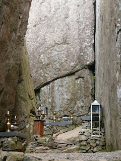
Shinseon-sa is famous for it's rock carvings in a U-shaped grotto behind the temple. They are believed to be the remains of the first cave temple built during the Shilla period (57B.C - 668A.D).
신선사는 절 뒤에 있는 U자 모양의 작은 동굴 안에 있는 바위조각으로 유명하다.
사람들은 그 조각들을 신라시대(B.C.57 - A.D.668)에 세워졌던 첫 동굴사원의 유물이라고 믿고 있다.


Looking forward from the temple to the blue hills of next week.
절에서부터 푸른 능선까지, 다음주 산행을 기대하며

Dang-gogae rest area where the trail hits the road yet again.
다시 산행을 시작할 당고개 휴식 공간.

Next weekend I'll be heading north from here for what should be a good walk as the trail joins the remains of the Busan Castle fortress walls.
다음 주말에는 이곳에서 북쪽으로 출발할 것이다. 부산(富山)산성 성벽의 잔존부분과 만나게 되는 산길이어서 틀림없이 멋진 산행이 될 것이다.

Monday 8 September 2008

To Soho

The Nakdong-jeongmaek ridge snaking north from Baekun-san (901m)

Summers now at its end here in Korea and with it my break from the 낙동정맥 trail.
The plan this first weekend back was to walk from Unmum-ryeong (the pass where I finished up at in June) 37km north to Dang-gogae on the eastern edge of Gyeong-ju provincial park.

Inside one of the mountain shelter/restaurants at Unmun-ryeong

First peak of the day

Saturday was a bit of a grey one with rain never far from the hills and visibility not so great. I set off with a pretty big group of walkers who were heading to Munbok-san, a big mountain on the end of a ridge which branches NW from the 1st peak while the Nakdong-jeongmaek heads NE. With the poor weather I decided to join them and save the next section of trail for the promised good weather on sunday.

Two of the posse cutting a bottle of Makali to make two cups.

The couple above were both seriously overloaded with food yet grossly underprepared. They had 4 bottles of makali (rice wine) a kilo of Chokbal (pigs feet meat) and a decent pile of Kimbab yet no water; that was my contribution.

With the self-designated hiking leader...he had a GPS and a walkie-talkie.

Looking at the Nakdong-jeongmaek from the trail to Munbok-san

Wahang village below Goheon-san, back on the trail.

Sunday dawned fine and incredibly clear for the climb up Goheon-san, the last peak over 1000m until near the end of this trek.

South-west views to Neungdong-san, a mountain I crossed in June.

Goheon-san summit (1033m). Yo, thats two photos joined together.


Large new cairn on Goheon-san. The wooden bit is temporary, I reckon a plaque is going in there.

The open ridge trail to Baekun-san, the next peak and a mean climb with no shade.

Daeseong-sa temple

This little temple doesn't appear on the maps and I wouldve mistaken it for a farmers hut had it not been for the sign.

Inside Daeseong-sa

Baekun-san (901m)

From Baekun-san the ridge trail became very thin and overgrown as most walkers take another route down. I ended up calling it a day in an area called Soho, a pretty trendy place by rural korean standards.

The future of rural Korea

flash houses below Soho-gogae pass

Soho-cheon stream

Next weekend is Korean thanksgiving (chuseok) I hope to walk at least one, maybe two days between Sat and Monday.
-cheers